With: Courmayeur
By: Elisa Bessega
Skiers: Rudy Bucella, Mauro Marassi, Fabio Rolle & Letizia Nicolino
A skimo trip in Courmayeur
Val Ferret: ski touring on the balcony of Mont Blanc
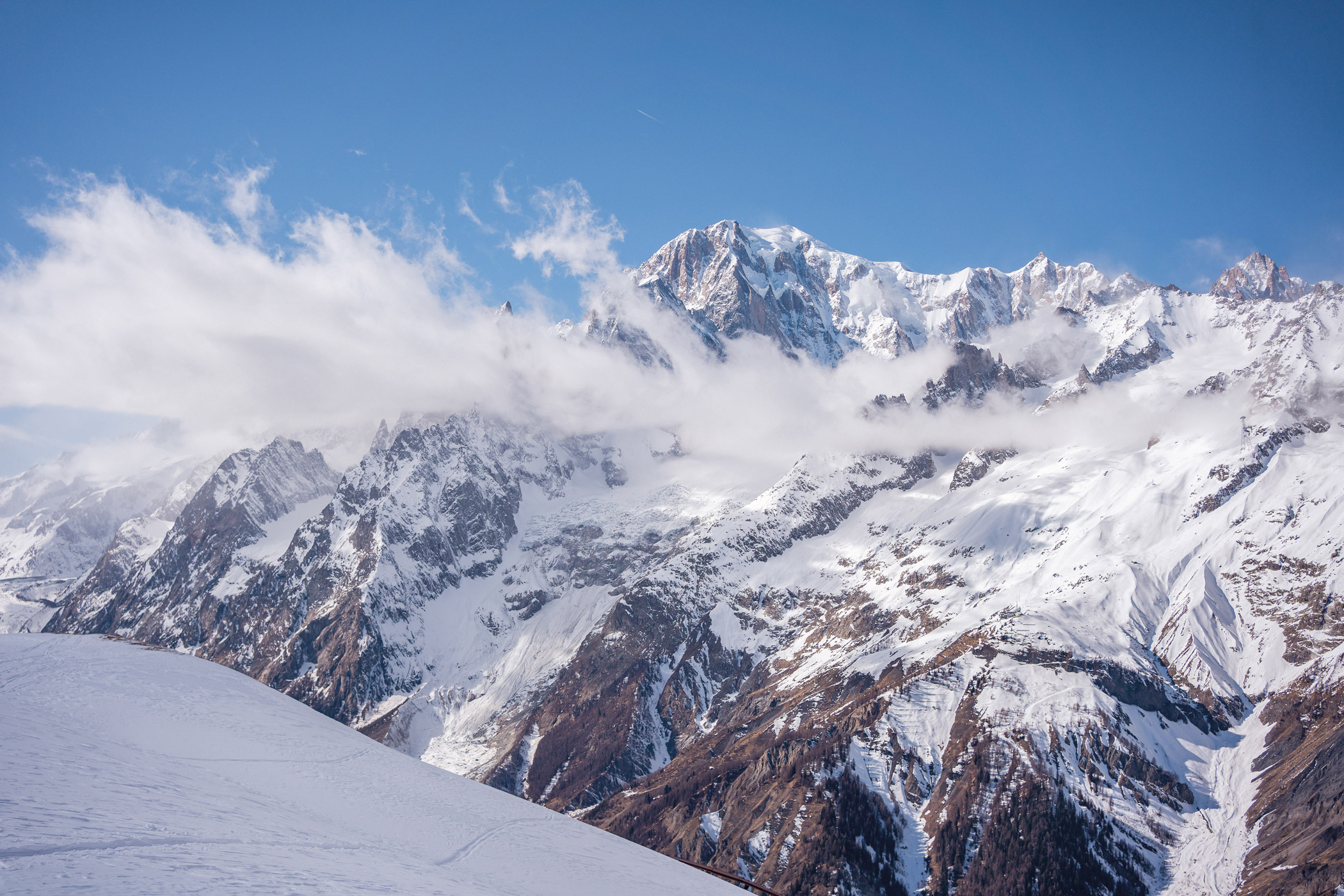
If you think about Courmayeur immediately your mind will fly to the great spaces of the highest peaks in Europe and to the most exclusive ski areas in the Alps. You can imagine reaching the sky thanks to Skyway Monte Bianco, the iconic cableway that takes you to the 3466 meters of Punta Helbronner, or to the endless off-piste routes that branch out from up there between peaks and glaciers to the bottom of the valley.
But there is another way to be enchanted by the majesty of the Valdostano massif, and it is perhaps the one that allows you to better grasp it in all its majesty: from afar, skis and skins “at your feet”, along the wild panoramic slopes of the Val Ferret. They call it balcony of Mont Blanc, and not without reason: lying opposite the massif, it runs parallel to the long crest of the Grandes Jorasses and allows you to observe all the peaks.


Slow tourism in front of the highest peaks of Europe
A few minutes from the center of Courmayeur, the valley retains an authentic and uncontaminated spirit that makes it the ideal destination for lovers of a less fashionable and more exploratory mountain. It is perhaps best known and most popular in its summer guise, as a crossing point of the famous Tour of Mont Blanc, a 170-kilometer hike whose route follows the northern slopes of the valley halfway up, crossing meadows, mountain pastures and sparse groves, immersed in a truly alpine landscape. Those same slopes, during winter time, turn into an ideal terrain for backcountry enthusiasts. With the arrival of the snow, the road that runs through the entire valley up to an altitude of 1850m is closed to traffic and converted into a long and suggestive cross-country track which, from Planpincieux, winds with numerous variations up to the Lavachey locality for a total length of 22 kilometers. There you will meet cross-country skiers, simple walkers enjoying the silence and tranquility of the wonderful forests of the valley floor, and finally ski mountaineers, for whom the slopes represent a convenient starting point for exploring the slopes above.


Backcountry for everyone
Ski mountaineering itineraries present developments and levels of difficulty suitable for everyone. What unites them is the possibility of enjoying excellent snow without facing excessive differences in height (between 700 and 1200 meters) in an area where it would otherwise be very difficult to start from the valley with skins, given the considerable elevation of the peaks of the Blanc chain. In fact, on the orographic right of the valley, facing south-east, stand the majestic Grandes Jorasses (4208m), the aesthetic Dent du Géant (4013m), the Triolet and Leschaux group, almost inaccessible from the bottom of the valley due to the long kilometers of portage and of the technical level reserved for a few experts. The ideal side for skin lovers is the opposite one, facing north/north west, made up of large shady slopes where snow remains soft and sheltered for a long time. From there you can reach the numerous peaks that delimit Val Ferret on the left: starting from the itineraries closest to the village of Planpincieux you will find the panoramic Mont de la Saxe and Testa Bernarda, which respectively rise up to 2346m and 2533m, or, to follow, the more demanding Tête entre deux Sauts (2728m), Mont Chéarfiere (2826m) and Bella Colomba (2701m), up to the marvelous Tête de Ferret, which with its 2714 meters closes the valley to the northeast on the border with Switzerland. In spring, when the road opens to traffic again (normally from mid-May), it is possible to avoid the long approach along the cross-country track and to explore the steep and demanding northernmost slopes of the chain, entering the less frequented and more wilderness of the valley.


Mont de la Saxe & Testa Bernarda
The itinerary proposed here represents the ideal compromise to enjoy a majestic panorama in relative safety (never let your guard down!) and on excellent snow, it does not involve high technical difficulties and the difference in height is within everyone’s reach: a satisfying excursion when the conditions at high altitudes are not the best or during snowfalls, immersed in the magic of sparse and dusty groves.
It starts from the town of Planpincieux (1583m), reachable in about ten minutes by car from Courmayeur during the week, or by shuttle bus on holidays and during the high season. After a few hundred meters along the cross-country track, you can go up into the woods following a comfortable forest road, then continue overcoming some bumps in the open field until you will reach the wide ridge of Mont de la Saxe (2346m): a viewpoint that will take your breath away. From here you can continue on the long ridge that leads to the top of Testa Bernarda with your gaze fixed to the left, enraptured by the succession of spiers, glaciers, and pinnacles of the most famous 4000 peaks in the Alps. You descend from the ascent route or, if the conditions are good, from the steeper slopes north of the summit: in both cases you will enjoy wonderful ski runs on wide and never too demanding slopes, kidnapped by the constant and imposing presence of the profile of Mont Blanc that stands out in front of the skiers all the time of the descent, guaranteeing unforgettable curves and moments.

Details
Height difference: 770m
Arrival altitude: 2533m
Duration: About 4 hours
Difficulty: MS
Exposed: NO
Starting point: Planpincieux. No access for cars on weekends and during the high season, easily reachable by shuttle bus departing from Courmayeur
Support points: There are no refugees along the route but there are several typical bars and cafes near the parking lot and along the cross-country track


